The Map Margin Matters: Reading Scale, Date and Purpose
Learn how to read county map scale, date and purpose so you can choose evidence that fits your question and avoid mistaking omissions or rough alignments for facts.
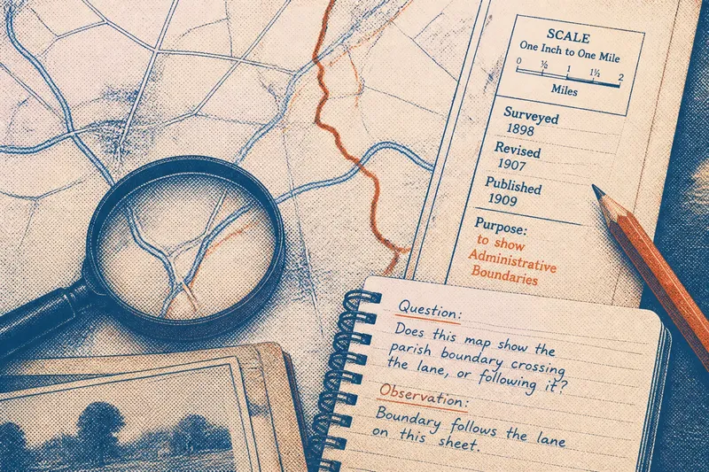
The common mistake with county maps is treating the clearest or oldest-looking sheet as the best evidence for every question. That can waste time and lead to a confident but mistaken reading: a road map may omit minor boundaries, while an estate plan may cover only one property. Before tracing a line or searching for a vanished feature, read the map margin for scale, date and purpose.
Those clues show what the mapmaker needed the sheet to do and which details mattered for that task. A map is like a tool in a drawer: a ruler suits one job and a sieve another, but neither is faulty because it cannot do both. Match the source to the question, then mark where its limits begin.
Start with the question the map must answer
A broad question such as “Where was the old county boundary?” can hide several different tasks. You might need its general course, the position of a particular bend, its location at a certain time, or the reason it was drawn there. Each calls for different evidence.
Write a question that can be checked on the sheet. “Does this map show the parish boundary crossing the lane, or following it?” gives you a feature and a relationship to inspect. “What does this old map tell me?” does not.
- Observation: The question concerns the broad location of a settlement or district. If the county map labels it, then use that map for orientation; otherwise seek a map with clearer place labels.
- Observation: The question concerns a lane, stream or boundary beside buildings. If the sheet shows those features distinctly, then compare their positions; otherwise look for a larger-scale map.
- Observation: The question concerns change over time. If two maps have compatible purposes and dates, then compare them; otherwise find a closer match before inferring change.
- Observation: The question concerns why a line was recorded. If the title or notes state the map’s purpose, then use that as context; otherwise consult related records rather than infer meaning from appearance.
- Observation: The map has a scale bar or written scale. If it is legible, then use it to judge the map’s level of detail; otherwise avoid precise distance claims.
- Observation: The margin includes survey, revision or publication wording. If these dates are distinguished, then record each separately; otherwise describe the date as uncertain rather than assigning one.
Keep the question beside your notes. It helps prevent a useful map from being asked to answer something it was never designed to show.
Scale sets the level of detail
Scale describes the relationship between distance on the map and distance on the ground. A small-scale map covers a large area but compresses detail; a large-scale map covers a smaller area and can show features more distinctly. The terms can feel counter-intuitive, so check the printed scale or scale bar rather than judging by the sheet’s physical size.
If a narrow lane appears to meet a parish boundary on a county map, that apparent junction may be a cartographic simplification. At that scale, a small shift on paper can correspond to a meaningful distance outdoors. The line’s thickness also matters: its centre may be hard to distinguish, especially on a worn or enlarged copy.
Try a closer-scale sheet for the same area, if one exists. Compare how it records the lane, boundary, stream or buildings, and note whether the apparent alignment persists. If no larger-scale map is available, describe the position as approximate rather than turning a broad depiction into a precise claim.
Digital zoom enlarges the image, not the information originally captured. A coarse map does not become a detailed survey when its pixels grow on screen. Cropping can also remove the scale bar or title, so retain an image of the whole sheet or record those details before examining a small area.
Dates explain some apparent disagreements
A map’s date may refer to its survey, revision, publication or later printing. Those are not always the same moment. A later print may preserve older information, while a map revised for one feature may still carry earlier details elsewhere.
Look around the title block, imprint and margin notes. Record the exact date wording and any distinction between survey and publication. If the sheet gives no clear date, describe it as undated rather than assigning a year from its style or a catalogue label alone.
When two maps disagree, ask first whether they show the same period. A lane might appear on one sheet and not another because it was added, abandoned, renamed or omitted in a later revision. A county boundary might also look different because the mapmaker used another source, not because the boundary moved.
Compare each map’s date and revision details, then look for the feature on another map from a compatible period. Keep visible evidence separate from interpretation: “The later sheet does not show the track” is an observation; “the track had disappeared” is a conclusion needing further support.
Purpose explains what a map leaves out
Maps are selective records. A road map gives prominence to routes; a land or estate plan may emphasise fields, ownership divisions and buildings; a county overview may orient readers across a broad area. Even a detailed map is selective because the mapmaker must decide which features suit the task and available space.
Read the title, legend, marginal notes and surrounding labels before treating a blank area as evidence that nothing was there. A missing footpath on a sheet made for another purpose may say more about the map’s priorities than the landscape. A clearly drawn boundary line does not, by itself, explain its legal or administrative meaning.
Ask what the map was made to help someone do: navigate, manage land, administer an area, sell property or provide a general view of the county. The answer will not settle every question, but it gives you a sound reason to expect some features to be prominent and others absent.
How should you check a county map?
What if the map has no scale bar?
Look for a written scale, grid or other marginal information that indicates how distance should be read. If none survives, use the sheet for broad relationships rather than exact distances, and note that its scale is unknown.
Can a later map confirm an earlier map?
A later map can provide a comparison, but cannot by itself confirm an earlier condition. Check whether both maps share a purpose and whether each records the feature in enough detail for a meaningful comparison.
Why does a map show a boundary but not name it?
The line may have mattered to the map’s task even if its name was unnecessary for the intended readers. Check the legend, nearby labels and other records for identification; do not assign an administrative role from appearance alone.
What should you do if the margin is missing?
Use any surviving title, legend or catalogue description to identify the sheet, but keep uncertainty visible in your notes. If its scale, date or purpose cannot be established, limit your claim to what the image plainly depicts.
Work through a mismatch in a fixed order
When a map does not seem to fit your question, check it systematically before switching sources. This stops a search for more maps from replacing a careful reading of the sheet already in front of you.
- Name the feature and relationship. Identify the boundary, route or settlement, then state what you need to know about it.
- Read the margin and legend. Record the title, scale, date wording, symbols, purpose and revision notes that are present.
- Check the scale against the task. Use broad maps for location and larger-scale maps for close relationships; do not treat screen enlargement as added detail.
- Compare the dates. Separate survey, revision and publication dates where given; if they are unclear, keep the time comparison tentative.
- Consider the map’s purpose. Treat an absent feature cautiously if it falls outside the map’s stated task.
- Choose a source for the specific gap. Seek a closer-scale sheet for position, a compatible date for change, or another kind of record for ownership or administrative meaning.
- Record the limit beside the finding. State what the map shows, what it does not establish and what remains uncertain.
Say you want to decide whether a small stream marked on a county map formed part of a parish boundary. The map shows both the stream and a boundary line, but its scale is broad and its legend does not identify the line. You record their apparent alignment, then compare a closer-scale map from a compatible period; if that map still does not identify the boundary, your answer is that the stream and line appear aligned, but the stream’s administrative role remains unresolved.
Separate what you see from what you infer
For each map, record its printed title, scale, date wording, stated purpose, source or collection details and the feature you inspected. Describe what is visible before adding what you think it means.
For instance, “a line meets the road near the bridge” describes the sheet. “This is the parish boundary at the bridge” identifies the line and may require another source. This distinction is useful when maps use similar symbols for features with different meanings.
When comparing sheets, use shared reference points where possible, such as a church, bridge or road junction. Record changes in labels and symbols as well as lines. If the maps lack enough detail for a close comparison, say so instead of forcing a match.
Match the map to the claim
The map margin is part of the evidence, not decoration. Scale sets the level of detail, date frames the moment represented, and purpose helps explain what the sheet includes or leaves out. Match all three to your question rather than asking one map to settle every aspect of a county’s past.
For a county map, a visible line is a clue to investigate, not automatically a precise boundary, a complete record or an explanation. Before tracing anything, note the map’s scale, date and purpose; then state clearly whether the evidence supports a firm identification or only a tentative alignment.